Introduction
On May 10th the UAS class met in Tomah to work on some research and development work on a wetland just outside of the city. The purpose of the flight was to get a baseline to look at the changes in vegetation that will occur over the next few months. Follow up flights will be done using a red edge in an effort to see what types of vegetation are where on the property. The goal of the flights is to be able to market the property to a business that can re purpose it as a wetland.
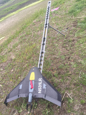 |
| Figure 1 |
Figure 1 above shows the Trimble UX5 prepared to launch.
 |
| Figure 2 |
Figure 2 above shows the Trimble UX5 in the carrying case. Peter Menet of Menet Aero brought the drone and executed the flight. Peter went over the pre flight check list with the class and allowed with assisting him as well.
 |
| Figure 3 |
Once the UX5 had completed its flight, professor Hupy and the class put up the DJI M600 with the rededge sensor. Above is the Real Time Kinematic (RTK) that was used to assist in real time corrections to assist with accuracy during the flight. Figure 4 below shows the tablet and controller that were used during the flight.
 |
| Figure 4 |
Figure 5 below is a photo of the M600 right before flight.
 |
| Figure 5 |


No comments:
Post a Comment